| Caryl and Brian's World Bike Tour |
|
Argentina Bicycle Touring Comments |
![]()
![]()
![]()
![]()
|
|
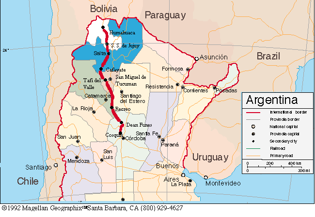
Putting a bike on an Argentine busGetting your bike on a bus in Argentina is not as easy as you would expect. Despite the huge size of the buses, there is not a lot of cargo hold space. In particular, the newest buses with their 2 floor passenger areas have extremely small cargo holds. Typically bus services expect you to completely take the bike apart; both wheels, pedals, and handle bars, and then wrap the bike in cardboard. Then you are to ship it on some bus, not necessarily the one you're on. If you really want the bike to go with you try to get on a bus that has just one passenger floor and try to travel on weekdays when fewer people travel. Also, try not to buy your tickets until you can be sure the bikes fit. It's almost impossible to get a refund if your bike doesn't fit and if you do get a refund it will be for only part of the total. If it looks like you'll be taking one of the 2 story buses make sure to ask again and again if there will be enough space for your bike on that bus. We found that by talking to the ticket agents and baggage handlers many times in advance makes them aware that you are concerned about your bikes. Often they'll remember you when the time comes for you to depart and they'll be more helpful in getting your bikes loaded. You will want to take your bike apart for these buses. Carry packing tape. At the bus station take off both pedals, turn the handle bar, and take off both wheels. We found that taping one wheel on each side of the frame protects the frame and results in a good, small package. If you have even the slightest possibility of taking buses you should carry a fork spacer in your gear to protect your front dropouts. Often you will have to take off the front wheel and the probability of your bike being dropped on the front drop-outs is quite high. Make sure to tape it in place if you do use it as it's not uncommon for them to fall out. If you need to find a fork spacer in Argentina, check only at the shops with the best, most expensive bikes. Cheap Argentine bikes don't use them when being shipped. They're called "protectores" and the front fork is called an "arco". Quebrada de Humahuaca, Jujuy provinceThe road running down the middle of the Quebrada is typically in fairly good condition, good pavement with few potholes. However, they seem to be continually working on the road as it often washes out. When we visited there was a large section being rebuilt and moved up hill which was all rough dirt. There were also 2 spots near the town of Volcan where you have to cross a stream. On a dry day they're not to deep, but if it's raining hard they could be quite deep. If you stick to the main road a touring bike with 1" tires should do fine. There may be a few spots where you have to walk for a km or two, places that are under construction. If you want to explore the side roads more you will want a mountain bike. Note that in the rain the side roads will be very, very muddy. Winds in the Quebrada are typically calm in the morning and howl in the afternoon. However, unlike the western U.S., winds here flow from south to north, from the lowlands up to the high altipano. We can only figure that the altiplano, being dry, gets hot first, the air rises and air in the lowlands flows up to fill the vacuum. The downhill slope of the road is not enough to overcome the headwinds. So ride early if you're headed downhill, late if you're going up. Traffic is pretty light especially during the midday siesta and we didn't have any particular problem with nasty drivers. There are a lot of buses and a noticeable number of trucks. Buses often honk to let you know they're coming. Get off the road if two trucks or buses are going to meet right where you are. Campgrounds between Humahuaca and Jujuy are at Humahuaca, Tilcara, and about 20 km before Jujuy. You can camp behind the gas station at Volcan, but it's not a particularly great campsite. Just north of the turn off to Purmamarca there is a small picnic area on the left side of the road. It has 2 picnic tables and clean water gushing from a spring. This would make a great campsite. Just south of the Purmamarca turnoff is a small truck stop style restaurant that serves inexpensive and just OK food. The best places to get groceries are at Tilcara and Humahuaca as the other towns have only teeny tiny kiosks. Note we did not check Maimara for groceries. If you're desperate for bike parts there is a place in Tilcara that rents and repairs bikes. It's right across from the driveway into the El Jardin camping. Otherwise your best bet for parts is in Jujuy. We located 2 bike shops. One is on Lavalle near Independencia. The other is 1 1/2 blocks closer to the plaza and 1/2 block south. The second shop seems to have better quality bikes. I happened to break my rear red flashing light at Jujuy. I was able to buy a new one for $3 from one of the many street vendors who sell them later that same night. Route 9 from Jujuy to SaltaTo get past Jujuy, take the highway around town, Rt. 9. Downtown especially in the evenings, can be total chaos with cars, buses, and pedestrians. As you continue on Rt. 9 toward Salta traffic continues to be heavy until you get to El Carmen. From here until just after La Cardera traffic is incredibly light, especially as you climb over the ridge. The road is well paved, although there are some spots where you have to cross streams. It is also extremely narrow from the point where you reach Lago Cienaga until La Cardera, which makes the lack of traffic even more important. There is a good climb over one of the sierras. It's probably a good 1,000 ft or more of about 6 to 7% grade. It's best to enter Salta either on Sunday morning or during siesta hours. Much of the road into and through town is wide and one way. It does narrow in the center of town, but remains one way. However, there are diagonally parked cars, cracks in the road, cars coming in from the sides, and buses and trucks passing you. Stay alert. Once you get past town and cross the river there is a small sidewalk that you can ride on. Between Jujuy and Salta there are 3 official campings, one at the base of Dique Cienaga, one in La Cardera, and the third in Vaquero. The one at Cienaga looks pretty nice from the road, but we didn't check it out. The one at Vaquero appears to be off the road, up a hill, away from the river and didn't look all that appealing from the road. To find the one at La Cardera when you get to the bridge that crosses the river into town, take the bridge and turn right either at the first dirt road or further up where the road makes a T. This road heads upriver and will take you right to the municipal camping. It costs $1 per person plus $3 per tent, has reasonably clean bathrooms and cold showers. There is a stream crossing just before the camping and it can be extremely slippery. You're likely to lose the bike right out from under you. Walk across. There are 2 great bike shops in Salta. One is at 678 Espana and the other, Manresa Bicicletas, is on Corrientes at the corner with Pellegrini phone (0387) 423-3359. Salta to CafayateThe road from Salta to Quilmes is a nice paved route with only a few creek crossings. If it's raining some of the creek crossings may be rather deep. The road seems to gradually climb and descend several times up until you get to the town of La Vina, although none of the hills are all that strenuous. From La Vina you seem to be mainly descending until you reach Alemania. From there until you get to Cafayate you will be climbing at an almost constant steady pace. For the most part it's not overly steep, but it's steep enough to make you really tired by the end of the day. Winds seem to typically be from north to south in the Quebrada de las Conchas, although don't count on it and don't expect the tailwind to be able to overcome the continual climb. La Vina is a good place to get extra food and water especially if you plan to camp in the Quebrada. In fact, it's a good idea to take enough food and water to allow for a night in the canyon because if there's a headwind you may not make it to Cafayate. La Vina is also your last stop for water until Cafayate. There is no potable water in the canyon that is easily accessible. The water of the creeks and river are all muddy. We did find a little ranch at Santa Barbara where we could get cold drinks and some sweet cakes. There were no empanadas as mentioned in the L.P. book. The lady also gave us several liters of water that was a little discolored but still potable. However, don't necessarily count on her being there for you to get drinks or water when you happen to go by. Somewhere in Santa Barbara is a well or spring where that water is coming from, however, we have no idea where it may be. Cafayate to Tafi del ValleIt's an easy ride from Cafayate to Quilmes with the exception of the 4.65 km up to the ruins. The paved road is very, very quiet and there are virtually no real hills worth mentioning. You do go through 2 small towns, the second of which has both a couple of small stores and a little restaurant. Eat here, the food at the ruins is expensive. The 5 km up to the ruins site is a washboard, sandy uphill ride and will take a good 1/2 hour to complete. You can camp at the ruins in the parking lot and only in the parking lot. They have an outside water faucet and super clean bathrooms that are open until 7 PM and reopen in the morning at 8 AM. Watch for thorns, what we call goat heads, in the parking lot. Check your tires before leaving. If you don't want to camp at the ruins there is a campground at Amaicha del Valle. However, to get to Amaicha it's exactly 22 km from the ruins site (folks at the ruins will tell you it's 18 km but they're wrong) and it's a good climb. It'll take about another 1 1/2 hours to get there. Continuing on from Amaicha you will begin one long, long climb. We never got an exact estimate of the altitude at the river, but we guess it to be around 1700 m. The pass is at 3040 m making for a total of 1260 m climbing, that's about 4400 ft for those of us who think that way. Note that because the pass is surrounded by mountains having over 4000 m height the pass looks deceivingly low. It's not all up as there are a few spots where the road descends and then climbs again. Once you leave Amaicha you climb a long, straight steady climb for several km. Then you zigzag through another small town going up quite steeply at this point. When you finally get past the second town you now head across the side of the mountain continuing a bit shallower but still steady climb. After finally getting through the long town and zigzags you'll be on a somewhat more level climb for a while. You pass a tiny observatory that does allow visitors if you are so inclined. There's one point where the road drops steeply, passes a creek, makes a sharp turn, and then climbs steeply again. You'll see a small white building, a little chapel, on the mountainside located just after the road makes 2 long switchbacks. Despite appearances, this still is not the top. You have many more km to go. The chapel has a covered patio, which is a great place to rest and eat lunch. After the chapel you will climb some more and then go down quite a bit. At the bottom of the hill, just before the final steep climb, is a great campsite off the road. There are several large shade trees, grass for the tent, and a creek with clear water that can be boiled or filtered. This is at exactly 46.74 km from the ruins parking lot or about 40 km from the intersection of Rt. 68 and RP 307. To this point you've been climbing almost 39 out of the 47 km and still have another 5 to 6 km climbing left to the pass. Once you reach the pass, marked by a stone monument, there are a few more small rolling hills left and then a continual, steep downhill for about 19 km until you reach Tafi. The road is paved over the pass. However, it is a rough pavement for a fair amount of the distance. The road on the eastside has better pavement than the west. Toward the top of the pass you may encounter a strong headwind in the afternoon and afternoon thunderstorms are not uncommon. Tafi del Valle to MonterosFrom Tafi del Valle down the mountain to the east is one incredibly spectacular ride. However, they do have trouble keeping the road open. Land slides do happen. Check on the road condition before going down and it's best not to go if it's raining hard. There is a bike shop at the bottom of the hill in the town of Monteros on the road bordering the south side of the plaza, one to two blocks east of the plaza. Route 157 and 60, Simoca to Dean FunesThis is one long, flat, boring road. If you're hurrying to get to Cordoba and don't want t take a bus this is a better alternative than the road going south from Monteros. The road through Monteros goes through bigger cities and has more traffic. If you're in Cafayate, want to go to Cordoba and have a lot of time, take the road that continues south through Belen and on into La Rioja. It'd probably be much more interesting, although it does mean missing the spectacular ride down from Tafi del Valle. Rt. 157 has light traffic. However, traffic increases dramatically when you reach Rt. 60 in the state of Cordoba. Much of the traffic is large semi trucks and buses. The road condition is good to excellent in most places. However, there are some sections in need of work. In particular the section going south from Frias for 28 km is full of potholes. The road condition improves dramatically in the state of Cordoba including being mowed along the edges. The section of Rt. 157 through the state of Tucuman goes through a tropical environment. Sugar cane and lots of jungle line the road. Camping opportunities are limited. You can camp at the service stations in Simoca. In the town about 10 km further south there's a great looking river-park and incredibly neat football field. The next opportunity to camp is at the YPF service station just past the town of La Madrid. Although the people, who run the service station, are really nice, the tent site options aren't good. However, there's just jungle on both sides of the highway for a long distance further south. So this is it for camping choices in the state of Tucuman. Things get better the further south you go. The surrounding landscape gets drier and there are more options for just pulling off. The state of Catamarca has a lot of side pullouts where you can camp. However, often these have quite a bit of litter. There are service stations at Lavalle, Frias, San Antonio, Recreo, and Quilino where you can camp. The best ones are the ACA station in San Antonio where they have nice picnic tables under trees and the YPF station at Quilino where they have auto camping sites behind the station and the cleanest bathrooms and showers. The YPF station at Frias is next to a little town plaza in which you can camp or if you continue down toward the Esso there are several picnic tables at which you can camp. Security is no problem. However, on Saturday nights the road by Frias turns into a practice run for the town's hot rod car team and they're up very, very late. Frias has a hotel, just past the YPF station, named Ana Maria. Recreo has Hotel Tula in the town center as well as a couple of Recedenciales. There's a hotel in Quilino next to the YPF station. We were told that there is a campground near Quilino about 4 km off the road, but we didn't go look for it. Also, there is a municipal camping in Dean Funes. We saw a sign for it as we left town. The sign was facing toward Cordoba. Large grocery stores were sometimes tricky to find. There was supposed to be one in Frias, but we didn't find it. Recreo has a sizable one just 1/2 block north of the plaza. We spotted a large Almacor store 2 blocks off the main road in Dean Funes as we rode through. Signs on the main road point to this store. Dean Funes to Capilla del MonteIf you want to head over to Capilla del Monte and the Sierras del Cordoba region you can take the long, paved way around to Cruz de Eje or you can cut across the mountains via dirt roads, mountain bike required. The second route is a rough dirt road with several fairly deep creek crossings and a lot of steep climbing. But, the scenery is well worth it. To head across the mountains; take the right turn about 15 km further south of Dean Funes at the tiny town of Los Pozos. For the first 19 km you'll be following signs pointing toward the town of Ischilin. Turn right in 8 km, left in 7 km, straight in 2 km. Turn right on the road that is just before you enter Ischilin. A sign at this intersection points toward the Museo Fader. Make sure to go visit Ischilin. You may be able to pitch a tent somewhere on their nicely mowed lawn, but we didn't ask. After leaving Ischilin you'll now go a full 23 km with no turns. After the first 8 km you pass the Museo Fader. We pitched our tent right in front of the gate and the caretaker didn't mind as long as we left room for his car to get by. After 23 km you get to a T intersection where you'll turn right. This will take you up over the last bit of climb and then down to Rt. 38. Turn left on Rt. 38 to head to Capilla del Monte. Creeks along this route are plentiful and clear so you can easily boil or filter water. You can also get water from someone in Ischilin. It comes directly from a well and we had no problems drinking it without filtering. There is also an almecen and bar in Ischilin where you can get cold drinks. Capilla del Monte to Villa Carlos PazRt 38 is paved all the way and is one of the nicest roads we've encountered in Argentina. That's probably because it's a toll road, but bikes are free It is still narrow with little or no shoulder. However, it is pothole free. Traffic way out at Capilla is fairly light. But it increases a lot as you get closer and closer to Villa Carlos Paz. Buses are numerous, but semi trucks are 1infrequent. Note that we traveled this road in late March, off-season. In high season the road is probably extremely busy. Bike shops are to be found in La Falda and Cosquin. Campgrounds are all along the road from Capilla to Cosquin and Villa Carlos Paz. Puerto Iquazu to Posadas via ArgentinaThere are 2 ways to take this ride, on the Argentina side or on the Paraguay side. We rode a bus along the Argentina route, so the comments here are based only on that bus ride. However, we did bike the Paraguay route. On the Argentina side the road is quite hilly and has a lot of truck and bus traffic in addition to lots of cars. For a lot of the route there is a wide paved shoulder. An exception is about 5 km or so right near Puerto Iguazu before you turn south to head down Rt. 12. Also, the closer to Posadas you get the more intermittent the shoulder becomes. Sometimes where there is no paved shoulder there is a dirt shoulder. In other cases the paved shoulder may be only on one side. And sometimes there is only grass alongside the road. There are probably a good 50 km or so of no shoulder in total. There are many more facilities along this route than the corresponding route in Paraguay. Campings can be found in several of the towns along the way as well as gas stations, restaurants, and grocery stores. |
|
Copyright © 1995-2011 by Caryl L. Bergeron - Distribution for personal use permitted. Distribution for other uses with written permission.
Acknowledgements
|