| Caryl and Brian's World Bike Tour |
|
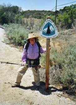
Pacific Crest Trail (2004) |
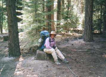
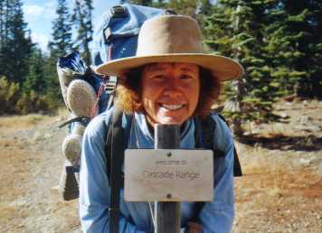
![]()
![]()
![]()
|
|
Brian and Caryl wish to dedicate their summer 2005 hike along the Pacific Crest Trail to the memory of Eric Johnson. Caryl’s cousin had a passion for the outdoors and for hiking. This led him to move to some of the remotest regions of Alaska. Here he was able to practice his chosen profession of assisting the native people with legal issues and participate in the great outdoor activities he so enjoyed. Eric left us quite suddenly and far too young on May 6, 2005.
We
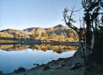
found ourselves in a high elevation alpine meadow under a cloudless, baby blue
sky. Our meadow was surrounded by an
erratic boulder wall, trimmed with a few remaining snow banks, and carpeted
with spring grass and tiny white, yellow, and pink flowers. Our narrow, muddy trail cut the meadow
diagonally and wound its way through boulders toward the summit of Mule Pass, a
mere 1/8 mile up trail, 100 vertical feet higher, 25 miles north of Tuolomne Meadows in Yosemite National Park, and 970 miles
from the Mexican border. It was a
picture perfect hiking day. A day we had
hoped would see us yet another 21 miles toward our goal, the Canadian
border. But, now that goal seemed to be
slipping away.
Everything
had started out so well. The idea to
hike the Pacific Crest National Scenic Trail, usually called the PCT, from
Mexico to Canada had percolated in our minds for many years. The first inklings probably were planted way
back when we lived in San Diego and went for hikes in the mountains around Idylwild. Many times
we’d hiked short sections of the nearby PCT, always making note of the
distinctive triangular shaped shield insignia used to mark the route. We knew the PCT was a border-to-border trail
that was, at that time, still under construction. We also thought anyone wanting to hike that
2600 plus miles in a single season had to be absolutely nuts. Yet, the seed had been planted. A
few years ago, while in Alaska, we hiked the four-day journey over the Chilkoot trail, the route most of the 1896 miners took to
get to the Klondike gold fields. At that
time that had been the longest backpacking trip we’d ever taken. Our feet were sore, our backs ached, and we
were so ready for a hot shower and “real” food.
But we both now had the hiking bug and it was time to try something more
ambitious. But, what? A few months later, while sitting on the rim
of Crater Lake in Oregon next to one of those ubiquitous PCT shields Brian
asked, “Have you ever thought about hiking the PCT?” “I had,” I replied, “but, I didn’t think you’d
want to do it.” Before
long we were putting plans together for a year 2004 hike. We’ve never done
anything quite this ambitious before, so many questions plagued our minds. What equipment different from our normal bike
touring gear would we need? How much
weight could we cut? What packs, boots,
clothes, stove, pots, plates, utensils, camera, first aid kit, tent, and
sleeping system would best meet our needs?
What kind of meals, how many calories, and what nutrition would we need? How could we keep from getting tired of our
menus? How and where would we get food
and supplies shipped? What supplies
could we find en route? How much would it all weigh? How much would it cost? How would we get to the resupply
towns? Would we need an ice axe or
crampons? How many miles per day could we expect to hike? Would we need different gear for the deserts,
high Sierras, or Washington? Would the
year be a good one for crossing the high passes early or would we find ourselves
bogged down in snow? Most important,
would we be able to remain both mentally and physically up to the challenge of
day after day hiking? This last
question, of all the rest, was possibly the biggest unknown. The challenges of bicycle touring were a well-known
quantity. This long distance hiking was
an entirely different matter.
Through
years of tracking PCT hikers, various organizations and authors have concluded
that the time you learn whether you have the “right stuff” to finish a PCT hike
is during those first few hundred miles.
In fact, it is believed that many would-be-thru-hikers
don’t even make it to mile 60. These are
the days your feet hurt and grow horrible blisters. Your pack is heavy with extra water and food
needed for this dry hiking environment.
You discover aches and pains in places you never knew you had. Your progress of around 20 miles per day
seems excruciating slow and that Canadian border a lifetime away. Many hikers simply do not fully grasp the
magnitude of what they’re attempting until after they start. It’s long.
It’s hard. It takes enormous
commitment and conviction. Most of all
it takes an “I won’t quite till I get there no matter what” attitude. This is hard enough for a couple, who have
been adventure traveling for many years.
It must be an order of magnitude more difficult for a solo hiker, a
hiker who is looking toward spending day after day after day alone. Needless to say we witnessed or heard of
several hikers dropping out within those first few days. Ignoring
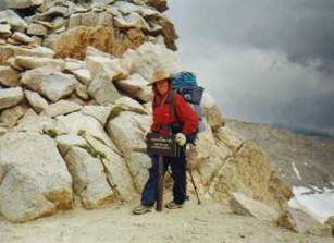
the blisters, sore feet, dry throats, and aching backs, we pushed on. From the Mexican border we climbed again and
again to get short hints of cool Jeffery pine filled mountain forests near
Julian, Idylwild, and then Big Bear. In between each we were forced to descend
once again into the scorching, treeless desert.
First to avoid private property in the cool mountains near Julian we
crossed an obscure desert nowhere called Scissors Crossing. Next we trudged through the sand choked and
wind blasted San Gregornio pass through which I-10
cuts and hundreds of windmills moan in the wind. Then we pierced our way westward past the
I-15 into the San Gabriel Mountains north of the gigantic Los Angeles
megalopolis. We turned north once again
to crest a couple more rows of mountains and skirt along the edge of the huge Tejon Ranch.
Finally, we descended once again to march our way north across the
Mojave Desert right on top of the concrete strip covering the California Aqueduct,
through the Tehachapi Mountains and, at long last,
into the much anticipated High Sierras.
In
those first eight weeks we learned so much.
We found out about “trail names”, odd nicknames given to or selected by
hikers which become their main identity for the rest of the hike, if not their
life. Names like Chaco
Man, Chef, K-Too, Wandering Monk, Brother John, Little John, Big John,
Scrambler, Captain Bly, Nelly Bly,
Cottonmouth, Salt and Pepper, Red Beard, Christy P, Rafter Jack, and, well,
Caryl and Brian. We found a unique
communication system exists all along the trail. Scraps of paper are tucked under rocks,
stuffed into cracks of wood, placed in trail registers, and tacked on message
boards.
We
learned about the blessings bestowed by the “trail angels.” Caches loaded with gallons and gallons of
water are strategically placed just where you need them the most. Some consist of new, sealed gallon jugs of
water neatly placed in a wooden bookshelf, complete with a trail register to
mark your passing. Others are a
hodge-podge of used jugs, filled from a tap, tied together with a string, and
just left sitting on the ground. Some
caches occasionally have candy, gatorade, and, in one
case, a cooler filled with beer and sodas.
Some are unexpected “gifts”, not listed on the water report sheet we so
carefully followed. But, each and every
one is a highly anticipated prize not to be skipped. We also learned that just when you depend on
one of these caches the most it’ll be empty.
We learned to carry a lot of water.
We learned to ask passing motorists for water at every opportunity. We learned just how precious this oft taken
for granted commodity really is. We
learned how to find the tiniest shady spot in the middle of the roasting
afternoon. How to find the smallest spot
possible for our tent. How to bushwack across fields and forests to find flat camping
spots. How to locate trickling
springs. How to read and follow the
guidebook, data book, and maps, and when not to believe its directions. How to look pathetic, hopeful, and harmless
when trying to hitch a ride into a “trail town”. We learned what equipment worked and what
didn’t. The pack definitely had to be
changed. And no matter how many repairs
we did, everything, especially our clothes, were bound to become tattered. We
discovered hiking styles as varied as the hikers. Some folks cooked, some did not. Some had food packages sent. Others bought food wherever they could. Some ate real meals, some survived on candy
bars and bagels. Some folks carried lots
of water, others just barely enough.
Some filtered, some used iodine, some took their chances. Some hiked 25 to 30 miles per day. Others hiked 15 to 20. Some hiked from sun up to sun down, some
started late and hiked after dark, and some just took each day as it came. Some spent 2 to 3 days in each town. Some hardly even stopped. Some drank and partied all the way north. Others stayed sober and avoided the
contact. Some seemed to have money to
burn, staying in hotels and eating in fine restaurants at every chance. Others, camped whenever possible and stuck to
fast food or grocery stores for their “real” food fix. Some tried to remain purists, hiking every
mile of the PCT and just the PCT. Many
took alternates or even skipped uninviting sections. No matter how each person chose to hike, one
and only rule remained true. You have to “hike your own hike” and don’t let
anyone else convince you to do otherwise. After
700 miles hiking we, at long last, reached the backcountry town known as
Kennedy Meadows. There’s not much there,
a few homes mostly of the mobile house variety, a couple primitive campgrounds,
and the store which, with it’s huge covered porch, is the meeting place for
locals and hikers alike. Absolutely
everyone stops in the store to buy food, pick up and send mail, chat on the
porch, wait for snow in the Sierras to melt, or to sign the register. Notes scribed in the register repeated the
same theme over and over, “no more desert”.
There’s almost a sense of euphoria, people thinking that having made it
this far, they could easily finish the rest.
But there were still many, many hard miles ahead and winter comes to
Washington so, so early. Being June 22,
late by PCT standards, we knew we had to push onward.
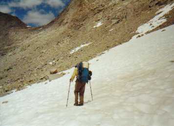
The
morning started well enough. We rose
with the sun, wolfed down a cold breakfast, packed and were on the trail by
7AM, a typical schedule for a 20-mile day.
Heading toward Burro Pass, the first of three we expected to climb that
day, we crossed Matterhorn creek once, twice, and
then approached it for the third and final time. Whereas the creek had been slow and calm at
the two previous crossings, here it gushed and frothed over rocks, branches,
and boulders as it roared downhill. No
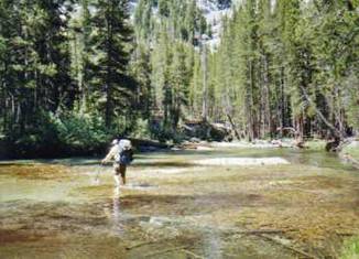
easy boulder path existed, not that my short legs could span. We shed the packs and shoes for an icy cold
wade. Here is where it all came to an
end. Brian tossed over his shoes. I followed suit, or at least tried. One shoe, a disobedient, errant left shoe
snagged onto a tree and dropped right into the creek. We immediately learned, modern hiking boots
don’t sink. As
my shoe slipped ever downstream we chased after it, Brian on the bank, me
sloshing through the water. We were about 16 miles from the nearest
civilization and trying to hike out with just one boot or wearing thin water
shoes seemed daunting. We slipped and
slid our way downstream until, finally we found the single boot floating upside
down in lazy circles in a small somewhat calm pool. I plunged into the thigh deep icy water thinking
that at any second an eddy would suddenly displace it back into the current and
it would once again be lost. I was wet
and cold, but at least I had everything in hand. Or
did I? My orthotic
and sock, so carefully stuffed into the shoe, had both come out and were still
somewhere in that wild creek. By this
time I was about as upset as I could possible get. Things were going terribly wrong and the
chances of finding that orthotic were slim. The sock didn’t matter, I had another. I was ready to give up, but Brian kept
searching and, amazingly, spotted it near the opposite side of the creek again
in a rather unstable looking pool. I
rushed across rocks and a tree branch, climbed down once again into knee deep
frigid water, reached down and managed to grab both sock and orthotic. Brian was
yelling something that sounded like “throw it to the other side”, but I wasn’t
about to let these things out of my grip.
Turns out he really was telling me to “go to the other side” and had I
followed that advice this would just have been a minor adventure of a long
trek. Rather I worked my way back across
the tree branch and rocks and just on the very last rock my foot slipped
straight down. It was only about a foot
drop, the sharp pain in my knee only lasted a second, and I could still
walk. So we carried on thinking I just
had a slight muscle strain at most. By
the time we made it to that high meadow just below Mule Pass it was becoming
clear, I had a serious injury.
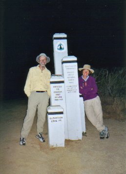
Eight
weeks to the day I sat on the very same stump where previously I had been surrounded
by SAR volunteers busily wrapping things around my leg, taking vital signs, and
asking all sorts of questions. Now, we
were alone, the Mono Village campground having been nearly deserted following
the Labor Day holiday. Our packs on our
backs, treking poles in hand, we were ready to press
on to finish as much of the trail as time and weather would allow. The other thru-hikers
we’d gotten to know were now well into Oregon and, based upon the few on-line
journals we found were suffering the ravages of early cold rains. We’d only be able to track their progress
through notes left in the trail registers where, we noticed, the number of
trail names we recognized grew fewer and fewer.
Only a handful of those we’d known would eventually finish. As
the remaining weeks wore on we left the alpine scenery of the High Sierras
behind, leaving the 10,000 and 9000-foot elevations for good. Three and four thousand foot climbs soon came
only once a week rather than daily.
Sharp, jagged glacier carved mountains gave way to smooth, round topped
hills punctuated by the high, snowy peaks of the volcanoes Lassen
and Shasta. Despite a mostly pine and
fir covered trail, long distances without any source of water returned the
further north we trod. It was late summer
in a year when the snowmelt was very early and now most seasonal creeks and
springs were dry. Once again, bottles of
water filled our packs. The trail became
somewhat less boulder strewn and easier to walk. Yet, our daily distances remained low, 15 to
18 miles, in part due to the short daylight hours but also due to the residual
ache in my leg. Apart
from one unusual mid September blizzard, we were blessed with a long lasting
Indian Summer. Days remained fairly warm
while nights grew colder. There was
virtually no rainfall, which made for near ideal hiking conditions through a
region that at normal thru hike time would have been
hot and miserable. The leaves changed
color and then dropped. Geese flew in
formation, always toward the south.
Hunters in their camouflage outfits trod quietly down the trails, always
on the alert for some sort of prey.
Backpackers rarely appeared. As
the middle of October approached we knew our time would be running out. The few north to south hikers we met told us
that rain had been plaguing the Pacific Northwest since mid September. It was only a matter of time, days not weeks,
when the first winter snowstorm would blast its way southward leaving a trail
covered in snow.
Despite
the unexpected interruption in our hike, we both feel it was very
successful. We’ve proven to ourselves
that we can accomplish and even thrive on this kind of lifestyle. That final, most important question has been
answered. If we can remain healthy, we
can remain mentally up to the challenge.
Are we upset that we didn’t finish in one year? Somewhat, but not too much. It would have been nice to finish with the
other hikers in our group, to be done with this lifetime objective, and to be
moving on to whatever comes next.
However, with the early and continual rains in Oregon and Washington,
with the 25 plus mile per day pace, and the constant pressure to carry-on each
and every day, we’re not entirely convinced we would have enjoyed it. Now we have the entire summer, June, July,
August, and September, the best possible weather months, to finish the
rest. Besides, we feel it’s quite remarkable
that I was even able to get back on the trail to finish an additional 530
miles. So we feel pretty good and raring
and ready to finish next summer. It’ll
be PCT thru-hike phase III. |
|
Copyright © 1995-2011 by Caryl L. Bergeron - Distribution for personal use permitted. Distribution for other uses with written permission.
Acknowledgements
|