| Caryl and Brian's World Bike Tour |
|
Great Divide Bicycle Route Summer 2000 |
![]()
![]()
![]()
|
|
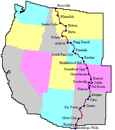
Adventure Cycling Association's Great Divide Mountain Bike Route, known as the GDMBR by those who ride it, extends from the tiny town of Roosville, MT at the U.S./Canadian border to the border station of Antelope Wells at the U.S./Mexican border. At 2,465 miles in length it is the longest mapped off-road bike route in the world. It follows 80% dirt road, 10% paved road, and 10% simple dirt trails. It crosses the continental divide 27 times, has a highest altitude of 11,900 ft., and passes through the states of New Mexico, Colorado, Wyoming, Idaho, and Montana. Great Divide Mountain Bike Route - 2000 |
|
Copyright © 1995-2011 by Caryl L. Bergeron - Distribution for personal use permitted. Distribution for other uses with written permission.
Acknowledgements
|