August
2001
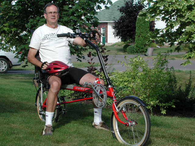
The author and his new bicycle
Click here to view more pictures of the author
and his family.
For 2001 my bike buddy Tom and I had planned a five-day
“Rails to Trails” trip on Prince Edward Island, doing the Island from
tip-to-tip. At the last minute
Tom cancelled out, however, leaving me with a bit of a dilemma.
I had the option of doing the trip solo, of course, but the prospect of
covering many kilometres of gravel paths alone seemed, well, boring.
Instead, I decided to take five consecutive short work weeks, watch the
weather, watch my office timetable to make sure I would miss nothing critical,
and do a series of one-per-week day trips on the Island - sampling the terrain
and scenery as thoroughly as possible. All
kinds of pictures of the Island, by the way, are available through www.gov.pe.ca/.
Here’s how it went:
24 July 24 2001- 84.75 km
I parked the car at the Wood Islands ferry terminal
just as cars began loading for the 10:00 crossing. The day was warm and clear, with a light breeze from the
southwest, and I set out light of heart, heading east towards Cape Bear at the
southeastern extremity of the Island. A
smog warning was issued that morning, but of course I didn’t know about that
until later.
A month or two earlier, in a fit of purist zeal,
I had purchased a Brooks leather saddle to replace the gel-filled standard
that came with my Trek 520. I had
heard that a leather saddle, once properly broken-in, offers absolutely the
most comfortable ride possible. The
break-in period is three months, however, with no clear indication of how
frequently or for what distance the bike is to be ridden during that period. Clearly, my three months weren’t up. From the outset, each little bump sent a shockwave through
the middle-aged butt, and it was clear it would not get any easier.
Nevertheless, for the initial leg to Cape Bear,
the highway was smooth as silk, and nearly flat, and I made excellent time
with a following breeze. The
first ten km or so were through cool woodland, which then opened into cottage
and farm country on a high plain with the ocean glassy and grey to the right.
The route passed lush Rossignol Estates, the only winery on Prince
Edward Island, before turning north. The
sight of extensive vinyards is a relatively new one on PEI, and one that I
hope becomes more common. The
highway ends at the Cape Bear Lighthouse, a pretty place but undistinguished -
except for the historical footnote that this was the first shore-based station
to have heard the Titanic’s distress call on the night it sank.
A short jog north led to another left-hand turn,
the highway now following Murray River westward, through Murray Harbour to the
community of Murray River itself. This
is a fun ride, along lightly-travelled roads with gentle (mostly) hills.
Murray Harbour itself is one of the more picturesque communities on the
Island, well worth a photo-stop. My
own pictures were looking downriver, at a collection of white lobster boats
moored against a wood-piled wharf.
Murray River is almost as picturesque.
By the time I arrived, however, the heat was becoming oppressive; and
the prime attraction was the air-conditioned comfort of an Esso station by the
bridge, where I sipped a diet Pepsi and stoked up on the Canadian
wonder-snack, “Fruit-To-Go,” while considering my next move.
The heat and growing humidity mitigated against my original plan of
following the shoreline northwards to Montague, so I decided to take the more
direct, but still picturesque, route via highway 4.
It would have been at about this time that Environment Canada issued
only its second-ever smog alert for PEI.
The blanket of dirty air that had been squatting for many days,
toad-like, over the northeastern US and parts of Ontario, had finally made it
to the usually-pure Maritimes.
Riding north, the chosen route passed “Buffaloland”
Provincial Park. Some 30 years
previously the Minister in charge of parks, Lorne Bonnell, eccentric then as
now, decided that what the Garden Province needed was more really big mammals;
so he imported a small herd of buffalo and fenced them off.
In several drives past park in recent years I have failed to see a
buffalo, and the viewing stand erected near the park entrance has always been
vacant. And yet, in an interview
only a couple of months previously, Dr. Bonnell had assured me they were still
around.
I puffed into Montague (“The Beautiful” - and
it is!) not long after noon. This
is one of the little communities in PEI in which I always thought I could live
in comfort. It’s not more than
a 40-minute drive from Charlottetown, situated on a lovely waterfront, with
direct access to the “Rails to Trails” bike paths that lead all over the
province, and with just about the right amount of local shopping and dining
opportunities. Noon-hour dining
should have been ideal at an attractive restaurant, serving on a deck
overlooking the waterfront. Standing
in the shade, however, the sweat pouring from my body, I considered that the
perspiration would be no less profuse were I to sit in the shade for lunch.
Prudently, I cycled up the street a short way to the air-conditioned
relative comfort of a Wendy’s/Tim Horton’s outlet.
Refreshed and filled, before setting off south I
visited the Garden of the Gulf Museum on the main road next to the river.
Established in 1958, this tiny museum has the distinction of being the
oldest in the province, opening a few months earlier than the almost-as-tiny
one in Charlottetown, the Provincial capital.
A university student, alone in tending the place, almost pleaded to be
allowed to show me through it, there having been little or nothing else to
hold her attention so far that day. The
collection is perhaps a bit heavy on 18th and 19th
century military paraphernalia, but to her mind the pride and joy of the place
is a circa 1872 high chair, of wood, leather and cane - that with a
flip of a lever behind the seat converts to a lower-to-the-ground stroller,
and yet again to a child’s rocking chair. It was much superior, she thought, to anything available in
the 21st century.
When she learned that I was a geologist, she had
to show me the museum’s rock collection - of two rocks. The first was a
fossil fish that she believed to be from Prince Edward Island - “more than a
million years old” according to the accompanying card.
I was hard-pressed to find a fish in the specimen, and of course knew
that the PEI rocks are in the neighbourhood of 285 my old.
The other specimen was a rather large piece of “fossilized wood”
which arguably was not a fossil at all. I
left my phone number for the curator, with the offer that, should she give me
a call, probably I could donate a much better specimen that was definitely a
fossil.
By now the heat and humidity were oppressive and,
even without having been told of the smog warning, I could tell that the air
was “not right.” I decided to
head straight south, about 25 km, back to Wood Islands and the car.“It’s a hilly road,” the museum guide said; and she was
right. As is so often the case on
rides in such conditions, and even knowing that I started and finished this
leg of the trip at sea level, I
was pretty sure the uphills were both more frequent and steeper than the
downhills. Stops at the top of
each hill to gulp more water were followed by downhill coasts, in a desperate
attempt to invoke evaporative cooling and to relieve the Brooks-tortured butt
from excessive pressure. The
hills themselves merged seamlessly ahead of me into the smoggy haze; and in
truth the only thing that kept me going towards the end was the certain
knowledge that; if I gave up, there was no easy way home.
I did make it, of course, and at need could have
ridden a few more kilometres, but it was a treat to be in the car, all windows
open, for a breezy ride home. The
next morning, lying in bed as the clock radio came on, I sampled that raw
sensation in the throat that follows breathing bad air too deeply, as I
listened to a commentator describe the pathology resulting from breathing bad
air too deeply. Later that same
day I made the first of my serious inquiries about trading the Trek for a
recumbent. I was taking too many
shortcuts on the diamond frame; and I yearned for the salad days of my
personal biking history, when I felt comfortable whatever the distance or
terrain.
1 August 2001 - 80 km
The evening before ride day, 31 July, I picked up
my new (2001) Rans Tailwind.I had ridden, between this one and a bikeE, a total of perhaps ½ hour
on recumbents to that point. It
seemed easy enough turning lazy figure-eights in a nearby church parking lot,
however, and I was anxious to get started. I was pleasantly surprised to find that the bike could be carried on a
trunk-mounted rack by the simple expedient of flipping it and resting it on
the chainstays instead of the top tube. I
made a mental note about the long wheelbase, however, and resolved not to take
the car, with bike loaded, though any drive-throughs. As purchased, I had equipped the Tailwind with a rear carrier,
kickstand, bottle cages, bar-end mirror, and computer. The bike came equipped with “rat-trap” pedals, and I decided to
start with them, at least, until I gained riding confidence.
I thought that, since I would be riding an unfamiliar
bike, it would be better to stay on familiar roads for the first day out.
It was a sunny, warm morning with mild north winds making for a
pollution-free atmosphere. My
route took me north from Charlottetown on the Brackley Point Road, traversing
the Island to the entrance to the National Park.
The highway is nearly straight and a bit hilly, passing through mostly
agricultural land. There are no paved shoulders, but fortunately the traffic was
light.
I had read all of the literature on riding recumbents,
and some of the advice hit home immediately.
To begin with, recumbents really are slower on the hills, and the only
way to ride is to gear down and spin up.
In fact, I found that I needed a cadence at least ten percent higher
with the Rans than I did on the Trek. I
needed to remind myself repeatedly to relax my arms and shoulders and look way
ahead of me down the road. When I
did so I felt stable; otherwise I was wobbly.
Other lessons were sharper, and came later. Even though I was unfamiliar
with the bike, however, my AVS for the first 20 km or so to the National Park
entrance was perhaps slightly above what I would have managed on the Trek.
Clearly I was flying on the downhills.
It was time for some adjustments.
Before biking onward I eased the seatback one more notch towards a
reclining position, and moved it about 2 cm further to the rear on the top
tube. I felt better right away.
My first rest stop was at the Brackley Beach public area, and it was
here that I had my first encounter with the great interest that these bikes
attract. The interest was enhanced, of course, by the like-new gloss
and the cherry red colour in the sunshine.
Emerging from the washroom, I found a cyclist from Quebec taking a
really good look, and we ended up chatting for perhaps 15 minutes.
He was clearly knowledgeable, and said that, between his road bike and
his mountain bike, he does about 7,000 km per year.
Further down the shore road I pulled into the Stanhope Beach rest area
for a break, where a less knowledgeable onlooker came up and asked what my
“problem” was. As the
conversation evolved it became plain that he had considered recumbents as
“therapeutic” bicycles, for those who were unable to ride anything else.
A more typical, and brief, reaction, came from a road construction
worker who, as I rode by, smiled broadly and called out “...like the
bike!” Generally, the ‘bent
caused a lot of double-takes in this province where they remain quite
uncommon. It will take some
getting used to, but it was also kinda fun.
On the north shore road, though it was early yet,
I pulled into the fishing village of Cove Head for one of the famous fish
burgers offered at a roadside stand. Cove head has become quite “touristy”
with such stands, and with the constant coming and going of “deep-sea
fishing” cruises for tourists; but in fact it remains, at its core, a
working fishing village. It had been a few years since I had had a Cove Head
fish burger. Since my last I had
been diagnosed as type II diabetic and, as part of the therapy, had
drastically reduced the amount of fat in my diet.
The burger was dripping with the evidence of deep fat frying, but
nevertheless was as delicious as I remembered it to be.
I decided that I would permit the benefits of exercise to offset the
disbenefit of grease. Further on,
at Stanhope Beach, one of the Tourism Department’s “Out of the Sea and
Over the Coals” demonstrations of barbecued fish cooking was underway.
I filled up further on fat-free haddock and, most tasty, arctic char
grown in local fish farms.
The ride through the National park closely
parallels the shoreline, with a sand dune complex on the left blocking the
view of the ocean except for scattered breathtaking views.
To the right, the back bay (the dune system actually is a large
baymouth bar) is sparsely settled and dominated by a tall, vaguely
sinister-looking house on a point of land, brooding over the waters. The house, in fact, belongs to the President of the
University of Prince Edward Island. While
the view from its windows and decks is spectacular for those within it, it is
an intrusion on the landscape for those outside.
Turning south at Dalvay, at the east end of the
park, I left the sea breezes and had the wind at my back. I added a few km to the trip by taking Route 6 though
Tracadie to highway 2 (the “trans-PEI highway,” as it were, that extends
the full length of the Island) instead of cutting though Pleasant Grove to
Little York. By now I was passing
most of the cyclists that I encountered.
While I still needed to gear down and spin more on hills than would
have been the case on another bike, with the Tailwind I felt strong and fast
on level ground and downhills. I
was beginning to feel what I had read about - a sensation like being in an
aircraft when sweeping around the corners.
The route passed through Corran Ban, a tiny community on a large
estuary. To the left, the dark water looked as though it had been laid
out for a sinuous version of Olympic swimming trials, but the white floaters
were in fact supporting strings of cultured mussels. To the right, rows of hay rolls offered a sinuous
counterpoint.
Following highway 2 with its broad, paved,
shoulder back to Charlottetown I stopped at Jewell’s Country Store for
another break and a rest on their shaded porch.
Jewell’s also runs a large farm for both potatoes and market
vegetables, and much of the produce is their own.
As I turned onto their parking area I hit a significant bump and lost
both feet from the pedals. Unable
to replace them quickly, I ended up coasting, legs outstretched, across the
oncoming traffic; noting as I did so that a swap to the ill-named
“clipless” pedals was mandatory. There
simply is not enough pressure in a recumbent posture to keep the feet firmly
on unclipped pedals against the inevitable force of gravity.
Jewell’s is always a pleasant stop. The owners
keep a pen stocked with goats across the parking lot in front of the store,
from which they can wander up a set of steep ramps, to a fenced platform
perhaps 20m above the parking lot. Children
have great fun loading tin cans with goat snacks and then cranking them up to
the platform on hand-operated pulleys, at which point the cans tip into bowls
and the goats, who already have had great fun climbing steep “mountain
trails,” have great fun snacking.
Home again, I swapped pedals with my Cannondale
mountain bike, and (having so much fun!) decided to continue with a
circum-Charlottetown route. Maybe
I was a little tired, too. Approaching
one residential street corner my path was crossed by an elderly lady who did
the usual double-take and then hesitated.
I hesitated too, forgetting to gear down.
Reflexively, I decided that the best thing to do was go ahead and
negotiate my right-hand turn rather than stop.
Forgetting that the Rans has a 61-inch wheelbase, I moved too close to
the corner and struck the curb with the rear wheel on the way around.
Reflexively, I braked. Forgetting
that my feet were clipped to the pedals, I fell over unceremoniously,
incurring road rash and a cut (all of which will heal), four (count ‘em,
four) paint nicks to the frame, and a small shredded area on the seatback
webbing. I suppose I should be
happy at least that the anxiety over how long it would be until the first nick
was incurred has ended. It was thoughtful, and prescient, that Rans provided a bottle
of touch-up paint with the bike. There
was no other damage, fortunately, and the repairs look pretty good.
I noted that all of the nicks to the finish appeared to have been
caused when the chain slipped its moorings - perhaps to be expected when there
are in the neighbourhood of 50,000 links to clatter about.
Later that day, after supper, I went out again and completed the route
that I had started, taking great care to gear down before very intersection,
coming to a full stop at most.
I remember when I was thirteen or fourteen getting on
my old one-speed and riding for the day, day after day, all over everywhere.
I felt as though I could ride forever.
That’s how I felt on the recumbent.
At the end of the day I had modest soreness in the Achilles’ tendons,
and minor pain in one knee - all no doubt an adaptation response to a new
posture - but otherwise I felt wonderful.
I can hardly wait to get out again.
Now: who wants to buy a like-new Trek 520?
[Historical note: The Trek sold a couple of weeks later, for the full asking
price.]
10 August - 77.8 km
Still exploring longer rides from home base, I
left Charlottetown and headed west, through North River to Cornwall.
This first leg is a high-traffic section of the Trans-Canada highway,
mercifully with paved shoulders all the way.
At Cornwall the route turned left, and entered rolling countryside
through Meadowbank; eventually turning back to the east and crossing the West
River. Most of the Prince Edward
Island Coastline is characterized by rising sea levels, and consequently
anything big enough to be considered a “river” in local parlance is in
fact an estuary. So it is with
Charlottetown Harbour. The
harbour is, in fact, an large estuary, the bed of an ancient river that flowed
eastward into the Gulf of St. Lawrence four thousand years ago when the area
now traversed by the Confederation Bridge was a land bridge to the mainland.
The three branches of the harbour estuary are referred to respectively
(and unimaginatively) as the East (or Hillsborough), North and West Rivers.
My route crossed the West river, at which point it was constricted by
the footings for the bridge. Tidal
flushing cause powerful currents that reverse twice daily.
It’s a favourite “jumping-off spot” for teenagers wanting the
rush of diving into a safe current (because the current dies, away from the
bridge), and sure enough the early swim crowd was out in force.
I turned south on the Canoe Cove road, which
crossed a neck of land and rejoined the main road only 3 or 4 km further on at
the south shore. From here, the
ride westward past St. Peter’s Island had the sea on my left and visible
almost the whole way. Near the
community of Canoe Cove I dropped in to see my old friend Copthorne
(“Cop”) Macdonald. Cop makes
his living as a writer, and when his wife Bev Stetson retired as Executive
Director of the PEI Bar Association a couple of years ago they chose a move to
the country, where they have an old farmhouse (1840's I think) on 9 acres of
land. Since then Cop has
continued writing and working to improve the property, and Bev has enjoyed
being retired and working to improve the property.
Cop is the author of the modestly-successful “Towards Wisdom” and
“Getting a Life,” and has just had accepted for publication his most
ambitious work, “Matters of Consequence.”
He also maintains the “wisdom pages” at www.cop.com.
There was nothing heavy in this visit, however.
We compared notes on bikes (Bev had just gotten a new Cannondale
commuter) and sipped Gatorade in their comfy living room.
On my way west along the shore, after a few km
the road turned north and intersected the Trans-Canada Highway at the lunch
point, the Blue Goose Restaurant. I
had driven by this small roadside café for years without stopping, bemused at
the suggestive and slightly obscene name for the place. In fact it was air conditioned (important on a hot, sunny
day) with a standard menu, very tasty, and excellent friendly service.
I was able to park the Tailwind outside the window by my table, and had
fun watching the interest shown in it by locals and tourists alike.
After lunch the ride went north through the Bonshaw
Hills. This is the rugged
heartland of PEI, so to speak. As I had read once in a biking guidebook, in
the PEI hills, “If their altitude doesn’t daunt you their frequency
will.” This is fair comment.
Most of the next 25 km was a roller coaster, on which I used every
rational gearing combination the bike could offer.
It was necessary to gear way down on the steep hills (I hit first in
the granny gears on one particularly steep ascent) and my speeds ranged from a
low of 8 km/hr to a fun high of 65.
Knowing that I would be in the Appalachia of the
Island, as it were, I had decided to be prepared for dogs - brought along an
old container of pepper spray that I had lying around, never used, from a tour
not taken a few years before. Sure
enough on one of my slow ascents two dogs charged at me from a local yard -
one a Rottweiler cross, by the look of him, and the other a geriatric collie
along to view the action. I
stopped, hauled the pepper spray out of my fanny pack, stood and taunted:
“OK fellas, come and get it!” Lured
closer by an apparent easy mark they moved in.
I lunged forward across the frame of the bike (it only made sense to
interpose something) and fired. Nothing.
I aimed again and pressed the button again.
Nothing. The Rottweiler
looked meaningfully at the pepper spray can, and then at me, bared his fangs a
bit more and deepened his growl. At
this point I made up my mind at least to go down fighting but, as fortunately
is most often the case, these dogs were all bark and no bite.
Once it was clear that they would not actually attack, I walked the
bike until they became bored by the exercise, and continued on.
The terrain gradually smoothed out after Kelly’s
Cross, where I turned east back to Charlottetown. On a hilltop near Riverdale the view was so breathtaking that
I rummaged for my camera, only to find that I had left it behind in a fit of
weight conservatism, or something. The
country was rolling in that area, the fields a patchwork of pale golden grain
and dark green potatoes, dotted with white farm buildings.
The shadows of popcorn clouds in an intense blue sky moved slowly
across the landscape bringing it even more to life.
It was a timeless moment; I’m sure it looked just like this a century
or more ago.
The traffic picked up gradually on the way back to
Charlottetown, reaching its usual intensity once back on the Trans-Canada at
North River. Back home, I was
pleasantly surprise that I had plenty of pep.
It was time to be in, however, Although I had covered myself well with
sunscreen, my thighs were burning, and not from the exercise.
Something about the recumbent posture makes that part of the anatomy
particularly vulnerable to sunburn, apparently.
Dogs notwithstanding, my growing comfort level with the
‘bent is such that the next trip will be longer and on completely unfamiliar
roads.
17 August - 60.6 km
August 17th was a civic holiday in
Charlottetown, a day when the city fathers assumed that everyone would show up
to cheer the Gold Cup and Saucer parade, prelude to the Gold Cup and Saucer
pace at the Driving park the next night.
In fact, only those with small children watch the parade, along with
about 150,000 tourists. The rest
of us get out of town. The Gold
Cup and Saucer trophy dates from 1959, and goes to the winner of a series of
heats that culminate with the GC&S pace run at midnight Saturday.
It’s a real social event, and every year thousands who would never
dream of going to the horse races show up to pass the time and bet their two
dollars (or more) on the winner. The
lead-up to the big race has Faith McKenna, who as far as I know only sings
this once in public every year, dressed in a Gone-With-The-Wind spectacular
outfit, singing the “Island Hymn,” followed by the race, followed by the
tearing up of 10,000 tickets as everyone goes home before the actual
presentation of the trophy. All
this is just to say that I have no idea whether the prize is an actual gold
cup and saucer, or not. Few care.
Back to the 17th. This was also my wedding anniversary. It had not been possible to ride during the week, but Judy
offered me a guilt-free day on the bike - which allowed her a guilt free day
on horseback. We saved the formal
anniversary for dinner and a movie that evening. Since neither of us was working, the opportunity presented
itself for me to switch bikes, to my Cannondale mountain bike, and ride the
“Rails to Trails” from Charlottetown eastward and across the Island to St.
Peter’s. Judy would pick me up
in the afternoon after which a cool beer had been promised us both by friends
in the Cherry Hill area close by the trail.
The trails were dry, there having been no significant
rain for close to a month, and for the most part they were firm and smooth.
My bike was a hardtail with the addition of a suspension seatpost, but
in a pinch these trails can be ridden with a rigid frame bike.
I found, however, that the suspension fork was absolutely necessary on
the side trip that was taken. The
wind was gentle and from the southwest, pushing me onward the whole day.
Rail lines typically go through the less-than-scenic
parts of cities, and Charlottetown is no exception. But after ten minutes or less of construction yards, junk
(“recycling”) yards and a meat packing plant, the terrain changes quickly
to farmland and woods. The
fireweed was past its prime but still showed magenta blossoms over white seed
pods, contrasting sharply with brilliant yellow ragweed. I noted with interest that, in a few places, arctic cotton
puffs waved in the boglands; I have never seen the plant so far south.
The first leg of the trip, from Charlottetown to Mount
Stewart, was on mostly newly-constructed trail - the last portion to have been
completed on the Island. Local
farmers had maintained a barricade over sections of the line for years,
preventing completion of the project - because they felt that land should have
been given to them for their personal use when the rail lines were abandoned
(they had no good argument here; the original deeds were clear that ownership
reverted to the Province), and because they feared (rightly) the irritation
and that would be caused by snowmobilers in the winter and (wrongly) by
cyclists and hikers in the summer. After
Little York the trail parallels the upper reaches of the Hillsborough (East
River), offering scenery that encourages many stops and much photography. The last 5 km or so to Mount Stewart were low-lying and
cat-tail rich. Mount Stewart
itself is a small community now, much-declined from its heyday in the 1870's
when it lay at the centre of a rich shipbuilding industry.
Schooners built at Mount Stewart were sailed down the river on the
lowering tide (the Hillsborough, like most rivers on PEI, is in fact an
estuary and has little current generated by stream flow). The industry came to an end when, almost simultaneously, the
last of the old-growth hardwood forest in central PEI had been felled to
support the industry, and steam overtook sail as the propulsion method of
choice.
The trail developers had installed park benches or
small picnic shelters for users every two or three km, and even small lookouts
in one or two places. There were
no services available (unless you were prepared to leave the trails and travel
country roads) until Mount Stewart. There,
the Trailside Café had been operating for the past two or three years,
offering bikes for rent, local souvenirs and, most importantly, good food.
The Café is successor to the century-old general store on the site,
the building having been bought by Doug Deacon, son of Don (one of the prime
movers behind development of the Rails-to-Trails system), and restored as a
labour of love. I had a nice
salad and sandwich on a screened porch overlooking bike parking, and chatted
amiably with tourists who had come to rent equipment.
I was making good time, and decided to leave the trail
not far past Mount Stewart to visit the famous “Healing Springs” of Prince
Edward Island, not far from Cherry Hill.
The Springs are a part of folk culture on the Island.
They appear on no map and in no brochure, and there is no sign marking
the turnoff to them. It’s just as well; tourism would destroy their very spooky
charm. I had not visited the
springs for some years, but Doug Deacon was willing enough to remind me of the
directions - perhaps because he recognized me as an Islander. Even then I could sense his reluctance. This is not a place that one would want to show off to the
tourists, exactly.
The turnoff to the Springs leads onto a dirt track,
built by “believers” across several private woodlots to the immense
chagrin of the owners. It is
poorly maintained, in places so dusty and deeply-rutted as to be
accessible only by ATV’s, mountain bikes or hikers, and leads into
what can only be described as “darkest PEI.”
Three or four km along, the road terminates in a clearing in the woods,
empty except for the monuments. Leading
towards the large monument, like runway lights, are parallel rows small of
dark red Island-stone markers, each consisting of four or five progressively
smaller rocks - the largest a boulder perhaps the size of a human head, the
smallest only a pebble. The large
“monument” (for lack of a better word) is a bizarre assemblage of
boulders, cobbles and pebbles, of various provenance (green-black volcanic
rock, red Island sandstone, and miscellany).
These are stacked together in a crazy lattice-work perhaps 2m high,
reminiscent of a cancerous Stonehenge or a drunken inukshuk.
Mini-stacks of stones, like the “runway markers,” ascend from every
possible horizontal surface like turrets in Mordor. Adding to the general eeriness was that I was completely
alone. This was a scene that
would not be out of place in a re-make of the Blair Witch Project.
A few metres past the monument was the Healing
Spring itself. A rather
ordinary-looking natural spring in the middle of which yet another “runway
light” marker sat forlornly. From
the spring a PVC pipe led a short way down a steep hill, where the distal end
was tied to a small tree and terminated in a downspout.
Water from the spout poured into an old porcelain bathtub, which in
turn overflowed into a small stream. Variously
taped, wired or tied to the neighbouring tree trunks was a bizarre assortment
of icons - plastic flowers, rosaries, religious medallions, crucifixes in
wood, bronze and plastic, printed prayers (in French, oddly in this most
English of provinces), and photographs - presumably of those for whom healing
was sought. Particularly touching
were the pictures of small children, dressed up and smiling at the camera.
The trappings were Christian; the spiritual practice was something else
entirely.
On spec, I emptied my water bottles and refilled them
from the downspout. It tasted
good, and only later did I notice the sediment that accumulated in the
container. Later our post-ride
hosts who lived nearby, Art and Elsie Cameron, asked “if the sign was still
there at the spring.” “No
sign,” I said. “Ah, well, the Health Department keeps putting signs up
advising that the water is unfit for human consumption, and the Keepers of the
Spring keep taking them down.” They
knew of people in the neighbourhood who would drink nothing but the spring
water, however. Perhaps not a
coincidence, everyone they knew of in that category had been terminally ill at
the time. Art said that his
son-in-law was toying with the idea of slipping a large quantity of red food
colouring into the spring by way of creating a miracle.
Back on the trail and heading east, farmland
disappeared for several km, and the landscape became as barren as I have seen
it in PEI. About this time I
noticed that my front derailleur was misbehaving and stopped for a check.
The downfall of thinking that “it’s only a local trip,” is that
sometimes you fail to check the bike before travelling.
In the present case the derailleur cable was shredding itself to bits
at the seat tube end, hanging on by a single strand.
I was lucky that the trail was nearly flat; it was a simple matter to
use the adjusting screw to lock the front gear onto the large chain wheel and
ride on from there. I felt more
than a little foolish, though.
The trail crosses Hwy 2 at Morell, where there was
another rest stop, less elaborate than at Mount Stewart. The menu consisted
entirely of flavours of smoothie, but at least there was a vending machine for
Gatorade and the like. Past
Morell, the trail quicky homes in on the south shore of St. Peter’s Bay.
Riding swiftly on with the following wind I startled Great Blue Herons
wading in the shallows - which rose to improbable flight on wings that seemed
somehow too large to unfold. But
they did. St. Peter’s Bay is a major production area for cultured
mussels (as opposed, I suppose, to boorish, ill-mannered mussels); and strings
of black, white and brown buoys were ubiquitous, suspending the growing
shellfish above the bottom sand and mud.
St. Peter’s itself is a thriving little community,
from the fishery, from tourism and from the nearby Greenwich Dunes section of
the National Park. The dune
system visible across the bay, is reputedly the largest such assemblage
anywhere in eastern North America. My
day ended where Judy met me, at a small bike rental place attached to the
Visitor Information Centre. It
was an easy ride, and a visual treat. I
feel inspired to make next year the trip that had to be cancelled this summer.
25 August 2001 - 72.5 km
Getting the Tailwind onto a car trunk carrier is an
exercise that will take some getting used to.
To begin with there isn’t much space between the top tube and the
chainstays at the front end of the bike - barely enough to allow the carrier
arms to fit. That, and the chain
gets in the way. In addition, the
only practical way to hag the bike is upside down, and the chainstays do seem
a bit flimsy for the purpose (but they held up nicely). Finally there’s the matter of the seat. Just as you don’t want to hang a diamond frame bike in such
a way the that car exhaust empties against the bike tire, you need to take
care that the seat back on a recumbent is clear of the exhaust. On my car, that meant hanging the bike with the chainwheels
facing forward. I’m sure the
process will become less awkward with time.
I drove to my starting point, Kensington, about
40 minutes to the west, and parked my car near the centre of town where the
rail-trail line meets the main street. This
is one area in the province where cyclists are made very welcome, with signs
directing them to every possible attraction in the vicinity, and all kinds of
little stores of interest. The
day was clear with a gentle northerly breeze, and quite a bit cooler than in
recent weeks - only in the high teens. Over the course of the day I doubt if the temperature climbed
beyond the very low 20's.
I rode north, just as happy to be biking into the
wind when I felt strongest. The
roads here, and throughout this ride, lacked paved shoulders; but they were
smooth and clear, and the drivers were universally respectful. Traffic was not
a big issue.
Only a minute or so from the start found me out
in the country. Although
Kensington is (I think) the fourth or fifth largest town in Prince Edward
Island, it is still pretty small. A
fifteen minute ride brought me to the white spire of the Indian River Church,
home to some of the finest classical music to be heard in this part of Canada. Years ago the old church was to have been demolished thanks
to falling attendance, which would have been a shame given the architecture -
a Robert Harris Design with his classic, complexly-groined, hardwood ceiling.
The remaining parishioners would have none of it, and devised several
successful strategies for restoring the church to financial health.
One of these was to make use of the building, during the summer months,
for the “Indian River Festival,” which has attracted artists from all over
the world. Some of them have
commented to me that the acoustics in the building are the best that they have
ever played in, bar none; and the remote location means that concerts can be
recorded with virtually no extraneous noise.
The place is a treat to the eye, too - richly carved and painted.
Riding on, the road followed a high ridge with
the dark waters of Malpeque Bay on the left.
The country here, and throughout the ride, was gently rolling and
rural, with little woodland to break the checkerboard of potatoes, wheat and
hay grown in the area. At the tiny community of Malpeque the road turned right
and followed the north shore along Northumberland Strait. Big surf breaking on the distant beaches contrasted
startlingly with the blue-black of the ocean, and in places it seemed
imperative just to stop and look for a while.
Some of the vistas here make their way into almost every PEI wall
calendar I have seen.
The route entered Anne of Green Gables country.
This part of the north shore is only on the fringe of the
tourism-intensive areas farther east. The amusement parks don’t intrude as yet, nor the unsightly
little “attractions” - Ripley’s Believe it or Not Museum, King Tut’s
Tomb, Cap’n Bart’s Science Park. Instead,
rural homesteads, otherwise innocuous, bore the labels of the Anne of Green
Gables Museum, of a house where Lucy Maud Montgomery lived as a girl, of where
to go for “Matthew’s Trail rides,” and of the “official” Lake of
Shining Waters. Interestingly, on
this bright Saturday near the height of the tourist season, they all seemed
mostly deserted.
Approaching New London I was met by a spread-out group
of perhaps 30 loaded (their bikes, that is) tourists. Smiles and waves were
exchanged all ‘round, and I stopped to lend brief assistance to a pair near
the back of the back who were having mechanical problems. They must have been travelling for some time, I thought,
since they both expressed a lot of interest in the Tailwind as a
comfort-alternative for touring. The
only restaurant in New London is a seafood place by the water, and it turned out
to be quite adequate for lunch. The
accommodations were plain, but the windows in two sides of the dining room
overlooking New London Bay more than made up for it.
The service was friendly and very prompt and the food, while
unimaginative (breaded sole, for me) was well-cooked and tasty.
The staff cheerfully filled my bottles with ice water,
and I was off again, heading due south across Highway 2 (the main artery that
extends the full length of the Island, and into the rural Irish heart of PEI.
The tiny communities in this area are a dead giveaway: Breadalbane,
Shamrock, Emerald, Kinkora. I
detoured from my planned route to visit Emerald, one of the few places I had yet
to see in PEI, because I wanted to know if it was as green and lush (like
beautiful Kinkora to the south) as its reputation would have it.
It was.
Completing the circle back to Kensington the character
of the agriculture changed distinctly, to much more intensive potato farming.
Small wonder; the two huge potato processing plants nearby, owned by
Cavendish Farms (New Annan) and McCain’s (Borden), attract the crop like
magnets. Much of the land is leased, and the tenant farmers “mine”
the soil, ignoring sound rules of crop rotation and spraying intensively with
pesticides and, at harvest time, with herbicides to “kill” the above-ground
portion of the plants. There may be
lots of money in cultivating root crops, but they are the great environmental
scourge of Prince Edward Island.
I re-entered Kensington the way I left it -
suddenly. Riding in from the from
the south, the only clue of a change from country to town was a reduction in the
speed limit only seconds away from the main intersection.
Back at the start, the bike went onto the car more easily (practice makes
perfect) than in the morning. The
drive home was pleasant, the cool beer awaiting even more so.
And for next year, I’m waiting to hear from
anyone wanting to ride the Island tip-to-tip, on or off the Rails-to-Trails.
Click here to view more pictures of the
author and his family.
Email John
|